The Challenges of Tasking Across Multiple Commercial Satellite Imagery Data Providers
In the world of commercial satellite imagery, owning and operating your own satellite makes the planning and tasking of new image collection requests relatively straightforward. You simply task the satellite to do what you want.
While I described the process as simple, it is in fact much more complex - as you consider tasking across multiple satellite orbits, collection angles, lighting conditions, weather patterns, command and control, uplink and downlink ground station schedules, data backhaul networks, storage capacities, product production, and dissemination. Restated, the simple part is prioritizing your request on your own satellite.
As the majority of this blog’s readers do not own satellites, acquiring satellite imagery entails reaching out to a commercial satellite company. With numerous other clients seeking these services for image collection, many discover that their priority is now co-mingled with the prioritized requests of hundreds, or even thousands of other customers, all competing for attention in the collection queue. So tasking gets more complicated, for the customer and for the data provider.
Complexities in Choosing the Right Commercial Satellite Company for Your Collection Request(s)
Many questions arise when considering which commercial satellite company to place a collection request with:
How do I decide on the right commercial satellite company to approach for my collection request?
How does my collection request align with the company’s existing priorities and commitments?
What is the turnaround time for processing and delivering the requested imagery?
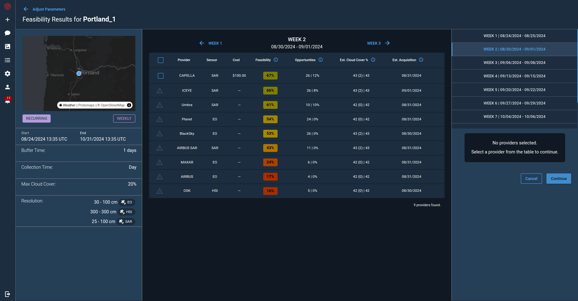
Navigating complexity is inherent in various stages of assessing and procuring services from commercial satellite data providers. This involves tasks such as aligning requirements with available sensor capabilities, gauging the feasibility of collection within the required timeline, understanding the impacts of weather and other collection planning variables, and determining acceptable pricing.
To grasp these variables for informed decision-making, reaching out to each satellite company individually is necessary, or alternatively, utilizing a reseller to facilitate the process on your behalf (though most resellers may not represent all available commercial options). Contacting and acquiring information from a commercial company involves a varied approach—some employ APIs, and others utilize web apps, while some prefer communication via email (often multiple emails).
After receiving responses from every commercial company, a thorough comparison is needed, evaluating the pros and cons concerning your timeline, quality specifications, and pricing thresholds. Frankly, relying on “professional judgment” based on past experiences becomes crucial in determining the best option. Following the decision on which company to move forward with, the order is placed, and then the “waiting for your collection” period ensues.
For all the variables listed above, waiting for your order to be collected is an uncertain process. Just because a satellite orbit passes within sight of your order, does not mean it will be collected. Competition with other orders and weather forecasts tend to be the primary limiting factors to collection. Even knowing these limiting factors, there is a pervasive lack of transparency from data providers to customers on the ongoing plan or feasibility to make a collection attempt and this is the customer’s perspective of uncertainty. Additionally, when risk to successfully collect an order increases because of new competition or unfavorable weather, customers are unaware, and therefore, unable to implement contingency planning for their requirement.
As the market for satellite imagery evolves to address more complex customer use cases like persistent monitoring, tip-and-cue scenarios, moving object custody tracking, and change detection driven imaging, customers and data providers both need ** ** a more substantial investment in feasibility and planning compared to a singular order. This effort may extend across multiple data providers, where one provider secures the initial collection, another manages the second collection, a third oversees the third collection, and the cycle continues on.
The Value of Solving Satellite Imagery Collection Challenges
Accessing the diversity and scale across the entire spectrum of the commercial remote sensing market with reliability, confidence, and optionality substantially broadens the scope and timeliness of use cases that can be fulfilled through the collection of satellite imagery. Much like the ride-sharing marketplace emerged from innovative software capabilities, matching a diverse market of vehicles (i.e satellites) with fluctuating rider requirements (i.e. remote sensing data user orders), the commercial satellite remote sensing marketplace is ready to be integrated with software in new, meaningful ways.
Several initiatives, both governmental (USG) and commercial, have been launched to address the challenge of distributing tasking and new collection requests within the commercial satellite marketplace. Most of these continue to be challenged by the disconnected and diverse nature of the system outlined above.
Thankfully, despite the multitude of variables to consider, there is still hope! The complexity, diversity, and scale inherent in the challenge of commercial satellite imagery collection are precisely the reasons why this problem is so valuable to solve.
CNTIENT’s Role in Tomorrow’s Satellite Operations
Cognitive Space is solving the complex issue of tasking across multiple data providers by drawing upon the technology, techniques, and insights honed through the development and real-world deployment of our CNTIENT.Optimize product. As we navigate this challenge, we anticipate its growing importance in the future – especially with the introduction of new constellations and evolving phenomenologies into orbit – something we’re well-prepared to confront and overcome.
CNTIENT.Optimize is a robust artificial intelligence and machine learning-powered solution for satellite constellation planning and scheduling. For further insights into our approach to employing AI/ML in constellation management, explore the blog written by our CTO, Dax Garner.
Applying AI/ML concepts from CNTIENT.Optimize, we are currently in the testing phase of our capability to efficiently navigate new imagery collection requests across various satellite imagery data providers. Our goal is to identify the optimal options that align with the variables of collection quality, priority, timelines, and pricing to improve the confidence and predictability of ordering new satellite collections.
We believe that AI and ML hold the key to unlocking critical value across various stages of the satellite imagery collection process. This encompasses AI/ML analytic tools asking the right questions, AI/ML for optimal satellite tasking selection (the problem we are solving), AI/ML in computer vision for object and feature extraction, and ultimately, closing the loop by returning to AI/ML tools to answer the question… and the next question.
Contact us to automate your satellite operations.