What is Remote Sensing?
Remote sensing is the method of measuring an area’s radiation by identifying and monitoring its physical characteristics. It enables us to observe and gather information about the Earth’s surface without direct physical contact.
Remote sensing involves the use of sensors mounted on various platforms such as satellites, unmanned aerial vehicles (UAVs), and aircraft to capture data from a distance. This data is then processed, analyzed, and transformed into valuable insights that allow for informed decision-making and a deeper understanding of the Earth’s dynamic processes.
The raw data collected through remote sensing contains a wealth of information. For data collected with electro-optical sensors, this information is embedded in the form of pixels, each representing a specific feature on the Earth’s surface. Through meticulous processing and analysis, these pixels are transformed into meaningful patterns, unveiling hidden insights. Whether it’s monitoring land use changes, assessing environmental health, or tracking the aftermath of a natural disaster, remote sensing enables the identification of subtle patterns that may elude the human eye.
Active vs Passive Sensors
The two main types of remote sensing are active and passive remote sensing. The process of active remote sensing is conducted via its own light or energy emission source. Passive remote sensing is conducted with reflected light or emissions.

Active sensors act as both a sender and a receiver, emitting pulses to determine the distance to the target and gather information about its properties. Active remote sensors have very few research condition restrictions. For example: Active remote sensing systems can function at any time of day since they don’t rely on sunlight for signal strength. One instance of active remote sensing in action is the Light Detection and Ranging (Lidar) remote sensing method used by the National Oceanic and Atmospheric Administration (NOAA) to create shoreline maps, support emergency response operations, and more.
Unlike active remote sensors, passive remote sensors don’t provide energy of their own for research subjects. Passive remote sensors rely on naturally occurring electromagnetic radiation — like sunlight. One example of passive remote sensing is the Landsat mission. Running for over 40 years, the Landsat mission is the longest-running Earth observation mission — leveraging passive remote sensing via satellites to monitor and collect data on Earth’s changing climate, land use, and environments.
Remote Sensing Technology, Devices, and Instruments
Various technologies empower scientists, researchers, and decision-makers to explore the intricacies of our planet. These tools function as essential sensors, capturing the complex dynamics of the Earth. There are many types of devices and instruments used for remote sensing, but some of the most commonly known are:
RADAR Sensing: Radar is an active remote sensing method that emits energy flow to reach a subject. Based on the energy’s travel time to and from the sensor (radar), the sensor can measure the subject’s distance. Synthetic Aperture Radar (SAR) on satellites enables all-weather imaging, ideal for applications like terrain mapping, disaster monitoring, and detecting subtle surface deformations. | LIDAR: Lidar, an acronym of "light detection and ranging" is an active remote sensing method that uses light impulses to identify a subject’s location and distance. It operates by emitting laser pulses toward the Earth's surface and measuring the time it takes for the light to return after hitting an object. By collecting these return signals, Lidar constructs highly accurate and detailed elevation models, capturing the vertical dimension of the terrain. |
Sounder: Sounder remote sensing utilizes sensors that detect and measure specific wavelengths of radiation emitted by the Earth's atmosphere. By studying the absorption and emission of these wavelengths, Sounders can profile various atmospheric parameters, including temperature, humidity, and trace gas concentrations, across different altitudes. | Spectrometer: Spectrometer active remote sensing identifies and studies spectral bands, breaking down incoming light into individual component or spectral bands. These bands represent specific wavelengths, allowing scientists to analyze the unique signatures of materials and phenomena across the electromagnetic spectrum. |
Radiometer: Radiometers quantify the intensity of electromagnetic radiation emitted by the Earth's surface. Unlike active remote sensing technologies, Radiometers passively observe the natural emission of radiation, measuring the radiance in specific spectral bands to extract information about the target. | Imaging Radiometer: An Imaging Radiometer is designed to capture radiometric data across specific spectral bands and translate this information into visual images. Unlike traditional radiometers, which measure the radiance without visualizing it, Imaging Radiometers provide a detailed and visual perspective of the subject. |
Accelerometer: An Accelerometer is designed to measure the acceleration of the platform or object on which it is mounted. In the context of remote sensing, this technology detects changes in speed per unit of time, providing valuable insights into the dynamic behavior of the observed subject. | Scatterometer: A Scatterometer operates by emitting microwave signals toward the Earth's surface and measuring the backscattered radiation. By analyzing the patterns and strength of these scattered signals, Scatterometers provide insights into surface properties such as roughness, wind speed, and soil moisture. |
The Process of Remote Sensing
The process of remote sensing consists of seven stages: energy source, radiation and atmosphere, interaction with subject, recording of energy, transmission, reception, and processing, interpretation and analysis, and application.
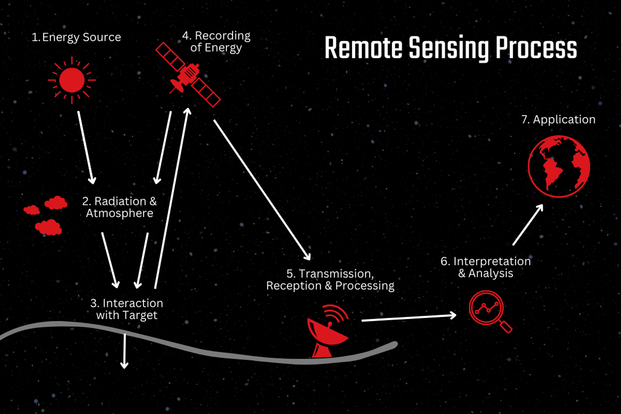
Energy source
Secure a form of energy that can provide electromagnetic energy for the subject of study (Examples: Sunlight, or a RADAR or LIDAR energy source).
Radiation and atmosphere
While the energy flows from its source to the subject, it will interact with the atmosphere it’s passing through.
Interaction with target
As the energy travels and connects with the subject, the way the subject interacts with the energy relies on the features of both the subject and the radiation.
Recording of energy
Once the energy is emitted by the subject, the remote sensor collects and records the electromagnetic radiation.
Transmission, reception, and processing
After the radiation is logged via the remote sensor, the electromagnetic radiation must be dispatched to a location for analysis and image interpretation.
Interpretation and analysis
The image created from the electromagnetic radiation is analyzed to gather information and data on the subject.
Application
Once the information and data are gathered from the image, we can better study the subject to gain new insights and predictions to resolve potential issues.
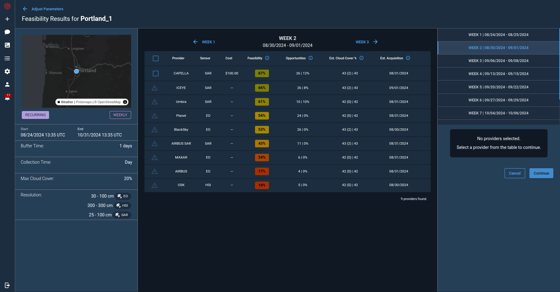
Optimize Remote Sensing with Cognitive Space
Remote sensing missions demand precision, adaptability, and scalability. However, conventional approaches often struggle to cope with the evolving demands of satellite operators. Cognitive Space’s CNTIENT platform is the next-generation solution for responsive optimization and adaptive mission planning of multi-spacecraft satellite constellations. CNTIENT enables satellite operators to tailor remote sensing mission planning, scale without disruption, and automate payload scheduling, link management, and prioritized tasking.
CNTIENT.Optimize is a robust, AI-powered satellite fleet management software service for real-world data collection. Satellite operators can optimize remote sensing mission operation according to sensor and payload characteristics, and build plans specifically tailored to their company’s unique business model and key operational requirements.
With CNTIENT.Optimize, space sector businesses are empowered to grow to become long-term viable operators and data providers for their customer base, whether government or commercial, on a global scale. Such independence from constant reliance on government funding will enable the space sector to become self-sustainable.
Contact us to automate your satellite operations.